


首页 > 搜索电子海图
搜索电子海图
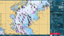
Electronic Ref. Charts(new pec)
"new pec" is a PC based navigational reference chart for small craft and leisure boats. The chart is full of information useful for leisure boating and angling in coastal waters, showing chart information including depth contours, position of set net fisheries, marinas and others in full colours.
* Interfaceable to GPS receivers* Bathymetric data and tide & tidal current data are available optionally.
查看详细内容
Depth Contour
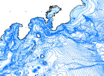
Digital bathmetric chart in the coastal zone.
- 选择类型